Evaluating Flood Hazard Mitigation through Sustainable Urban Drainage Systems in Bor, Jonglei State, South Sudan
Abstract:
In response to the escalating pressures of urbanization and population growth on the ecosystems and flood risks in Bor County, Jonglei State, South Sudan, this study proposes the implementation of Sustainable Urban Drainage Systems (SUDS) as a resilience-building measure. Through the design of open drainage channels featuring non-uniform flow, inclusive of main and sub-channels alongside infiltration wells, the research aims at mitigating flooding, enhancing water quality, and fostering sustainable development within the region. The necessity for managing substantial runoff volumes has been identified, with a decade of rainfall data employed to accommodate annual variability. The evaluation of SUDS techniques to mitigate flooding entails a customized design approach, integrating cost estimation with flood mitigation strategies and the assessment of short- and long-term co-benefits. Hydrological analysis of ten years of rainfall data facilitated the sizing of channels for storm events ranging from 2 to 5 years, with precipitation intensities between 73.82 and 93.08 mm/day, resulting in the planning of open trapezoidal channels with dimensions to support 5 $m^3/s$ flows. Moreover, infiltration wells, with diameters of 2–3 meters and depths of 3-5 meters, have demonstrated potential in reducing runoff volumes by up to 70% in a 0.5-hectare modelled area. The incorporation of drop structures aims to control slopes ranging from 6-15% in channels, thereby preventing erosion for flows up to 20 $m^3/s$. The adaptability of SUDS approaches, commonly applied in developed nations, to the tropical environment of Bor is scrutinized, highlighting the necessity for localized adaptation due to data limitations and modelling simplifications. The potential barriers posed by capital costs underscore the importance of a life cycle analysis. The success of SUDS implementation in Bor County is contingent upon community engagement, ensuring acceptance and ownership. It is recommended that low-cost, simplistic pilot projects, focusing initially on rain gardens and permeable pavements, precede large-scale implementation. Through strategic planning, SUDS hold the potential to enhance climate resilience in the expanding community of Bor County. An integrated technical analysis provides actionable solutions for flood mitigation, advocating for further monitoring and community-driven initiatives to transition SUDS from concept to reality.
1. Introduction
Nestled along the banks of the Al-Jabal River, Bor rises from the plains of Jonglei State in South Sudan as a seat of outstanding natural beauty and ongoing adversity. Situated approximately 87 miles (140 km) north of the capital city of Juba, at an elevation of 1,394 feet (432 meters), Bor serves as the administrative heart of the region, which extends across 12,000 $km^2$ between coordinates of 60°12'42.45" N and 31°34'54.42"E, with a studied area of 20.8 $km^2$, this diverse city is home to a mélange of ethnic sub-clans and rich cultural heritage. However, Bor still faces tremendous obstacles in the wake of the South Sudanese Civil War, which broke out in 2013 and resulted in extensive destruction and displacement. The city is beset by deteriorated infrastructure, a dearth of basic amenities like food, water, and medical care, and the constant fear of flooding during the rainy season. Nevertheless, the resilience and spirit of Bor's people persist as they work tirelessly to implement improved drainage systems, rebuild their communities, and create sustainable solutions for the future. With invested efforts to harness its strategic location, protect its vulnerable lands, and uplift its strong citizens, Bor can again thrive as an essential location in South Sudan.
The primary cause of floods in Bor is sub-factorial etiology, including physical reasons such as climate change and artificial action such as deforestation and extended prolonged rainfall, which can linger for days, weeks, or even months, causing the river Nile to overflow owing to excess water. Furthermore, seasonal flood events are caused by heavy seasonal rainfall or high water levels in rivers and other significant water bodies. The sustainable drainage system is one of the uses of the drainage system in urban areas that manages surface water so that it does not cause problems of inundation, flooding, and drought for the community, as well as being beneficial for environmental sustainability [1]. There is a change in the paradigm of a conventional drainage system from a drainage system that drains water to an eco-drain [2].
South Sudan is no exception to the increasingly severe flooding problem in urban areas that has spread throughout the developing globe. The utilities and facilities of most cities have not kept up with the nation's increasing urban growth, leaving areas at risk of floods during periods of prolonged precipitation. This is especially true in Bor County, which contains the rapidly growing town of Bor. Significant floods have struck Bor numerous times in the last ten years, causing infrastructural damage, population displacement, and fatalities. However, there are still a few viable options for managing stormwater. SUDS provides a workable solution to lessen the risk of floods while also helping the ecosystem and the local community. SUDS, also known as green infrastructures or ecologically conscious construction, are intended to mimic the environment's drainage mechanisms and absorb rainwater at the point of origin.
This represents a paradigm shift from conventional piped drainage, frequently worsening flooding problems. When properly planned and executed, SUDS can lower runoff volumes, promote groundwater recharge, improve water quality, and offer recreational and aesthetic benefits. Common SUDS approaches include permeable pavements, green roofs, bioretention, infiltration trenches, and artificial wetlands. SUDS has been widely embraced in the developed world, including portions of Asia, Europe, North America, and Australia [3]. However, more research is needed on implementing SUDS in smaller urban areas on the continent. With rapid urbanization occurring in secondary cities and towns, evaluating localized SUDS options suitable for these contexts is urgent. This is especially true for a location like Bor, which needs more centralized urban planning and drainage infrastructure.
Therefore, this study aims to assess the potential for SUDS to reduce flood risk and provide co-benefits in Bor. The specific objectives are to characterize the current stormwater issues and quantify flooding exposure in Bor. This will involve spatial analysis of floodplain zones and hydrological modeling to estimate runoff volumes and investigate community perspectives, needs, and acceptance regarding SUDS through surveys, focus groups, and stakeholder engagement. Nevertheless, social factors are critical considerations for sustainable implementation, and this is the design and model of localized SUDS for key high-risk areas identified in the objective above. Various configurations of bioretention, permeable pavements, infiltration trenches, and wetlands will be designed and simulated to estimate flood reduction. Conduct a life-cycle cost-benefit analysis to determine the economic feasibility of proposed SUDS compared to traditional drainage infrastructure and develop a framework for tailored SUDS guidelines and policies for Bor and similarly vulnerable secondary cities. This will facilitate future adoption and city-wide integration.
The goal of environmentally friendly SUDS is to lessen the adverse effects of urbanization on biodiversity, especially water control [4]. A thorough grasp of the water cycle is necessary for SUDS implementation to create more efficient and sustainable methods [5]. Key advancements in SUDS research have been made in several areas. Reducing pollution flow into waterways has improved water quality, which is good for public health and aquatic ecosystems [6]. SUDS has strengthened climate resilience through improved drainage systems and flood mitigation capacities [7]. Additionally, SUDS calls for increased public participation and knowledge, which enhances instruction on sustainable water management techniques [8].
The outcomes will provide empirical evidence on the potential of SUDS to create climate-resilient, sustainable urban environments in data-scarce regions [9]. Lessons learned can inform SUDS planning in Bor and other rapidly developing towns across South Sudan. Climate change is projected to increase rainfall variability, so urgent solutions are urgently needed to protect vulnerable communities [10]. SUDS presents a promising approach aligned with integrated flood risk management and green infrastructure goals. This research will elucidate the social, economic, and hydrological considerations for the successful implementation of a SUDS [11].
Compared to previous studies on SUDS in Africa concentrated in major cities, this work is distinctive in its focus on a secondary city with limited data availability. Much existing guidance on SUDS design is also based on temperate climates and centralized sewer networks, which is not transferable to a town like Bor. This project will help address these knowledge gaps by evaluating how SUDS can be adapted, integrated, and decentralized using localized data. The findings can facilitate evidence-based decision-making on sustainable stormwater management investments and policies [12].
This research will make scholarly and practical contributions to sustainable drainage approaches for climate change adaptation in growing settlements in South Sudan and other developing countries. The results will be disseminated through publications, policy briefs, and engagement with government agencies and communities in Bor. Successfully demonstrating SUDS can catalyze replication across other counties while enhancing resilience, public health, and environmental quality as Bor develops. This project will help Bor position itself at the forefront of sustainable stormwater management in South Sudan.
2. Literature Review
Drainage can be interpreted as an effort to control the quality of groundwater salinity. It concerns the drainage of surface water and groundwater [13]. Meanwhile, the urban drainage system is a unified system of technical and non-technical literature and means of urban drainage. The urban drainage system is a significant part of city infrastructure and is necessary for the water cycle within and beyond a metropolitan area [14]. The lack of proper functioning of urban drainage can be illustrated by the decline of urban drainage services caused, among other things, by the aging of infrastructure and less precise drainage management [15].
A consolidated the concepts of compensatory techniques in urban drainage design, which meant the introduction of several different measures, focusing on infiltration and storage capacity, to compensate for urban impacts on the hydrological cycle and improve urban drainage solutions concerning the SUDS concept [16]. In this case, the ideals of sustainable development are included in the drainage system design process; that is, impacts on the watershed due to drainage solutions may not be transferred in space or time. Moreover, besides contributing to sustainable development, drainage systems can be developed to improve urban design, manage environmental risks, and enhance the built environment [17].
Define SUDS as the interdisciplinary cooperation of water management, urban design, and landscape architecture, which considers all parts of the urban water cycle, combines water management function and urban design approaches, and facilitates ecological, economic, social, and cultural sustainability synergies [18]. According to “SUDS bring sensitivity to water into urban design,” The words ‘water sensitive’ define a new paradigm in integrated urban water cycle management that combines the various disciplines of engineering and environmental sciences associated with providing water services, including the protection of ecosystem environments in urban areas. Community values and aspirations of urban places necessarily govern urban design decisions and therefore water management practices. SUDS centers on integration at several levels, such as integrating potable water, wastewater, stormwater, and urban water management from the individual allotment scale to the urban scale [19].
Drainage systems are needed in developed urban areas because of the interaction between human activity and the natural water cycle. This interaction has two primary forms: the abstraction of water from the natural cycle to provide a water supply for human life and covering land with impervious surfaces that divert rainwater away from the local natural drainage system [20]. These two types of interactions give rise to two types of water that require drainage. The first type, wastewater, is water supplied to support life, maintain a standard of living, and satisfy industry needs. After use, if not drained properly, it could cause pollution and create health risks. Wastewater contains dissolved material, fine solids, and larger solids originating from WCs, washing of various sorts, industry, and other water uses [21].
The second type of water requiring drainage, stormwater, is rainwater (or water resulting from any form of precipitation) that has fallen on a built-up area. If stormwater were not drained properly, it would cause inconvenience, damage, flooding, and further health risks. It contains some pollutants from rain, the air, or the catchment surface. Urban drainage systems handle these two types of water to manage the impact on human life and the environment. Thus, urban drainage has two primary interfaces: the public and the environment [22].
The public is usually on the transmitting rather than receiving end of services from urban drainage (“flush and forget”), and this may partly explain the lack of public awareness and appreciation of a vital urban service. In many urban areas, drainage is based on an entirely artificial system of sewers—pipes and structures that collect and dispose of this water. In contrast, isolated or low-income communities typically have no main drainage. Wastewater is treated locally, and stormwater is drained naturally into the ground. These arrangements generally exist when the extent of urbanization has been limited [23].
Urban development reduces the soil's ability to absorb rainfall, which sets water resources under high pressure, creates higher volumes of water run-off, and increases the relative risks of pluvial flooding [24]. Furthermore, handling stormwater in the urban landscape is a crucial aspect because the rapid change of the urban structure, both with newly developed areas and densification of the current regions, is increasing the amount of hard, exploited, and impervious surfaces [25]. This dramatically impacts the environment's natural handling of stormwater, as the possibility of natural infiltration decreases. This shows that developed urban areas create a significantly higher peak runoff than before the area was formed, as the stormwaters conveyed more rapidly from the area. This occurrence is also called the flush effect [26].
Thus, a SUDS is designed to create a model that absorbs runoff water into the soil, often called infiltration. This infiltration system continues the runoff water into the drainage channel and is processed with filter-to-filter pollutants or waste that are involved in runoff water. The filtration system can use geotextiles or other media as pollutants or garbage. Drains and Infiltration Trenches Filter Drains and infiltration Trenches can use urban drainage systems on the right and left sides of the road as porous media that can run runoff water on the road and carry out temporary water treatment before the water is drained into the ground [27].
Designing SUDS also needs to be implemented in new areas or retrofitted into already-exploited areas. This could make it possible to create urban areas that can challenge climate change and urbanization, and complete multifunctional, sustainable, and flood-mitigated regulation of water flow should be considered an important aspect when designing a SUDS that can deliver ecosystem services to the urban environment and urban water management system [28]. Protecting and securing the regulating water-flow capacities of the urban ecosystem must be connected to related policies and choices of urban planning dealing with risk management [29].
The term drainage was derived from the English word "drain," which means to divert water [30]. Drainage can be defined as the natural or induced removal of water masses from the surface or subsurface of a location. A drainage system is a group of water networks used in civil engineering to minimize or remove surplus water from a location so that it does not cause inundation. According to this view, drainage plays a crucial function, mainly when the area is in a region with heavy rainfall [31]. The idea of drainage is significantly more explicit when applied to housing. Drainage in housing is a system that controls the entry and exit of clean and wastewater water so that it follows a specified path.
For urban residents to live in safety, comfort, cleanliness, and health, one component of public infrastructure is urban drainage. Its presence is crucial for a region, especially one that is residential. The city will be hit because of a poor and inefficient drainage system [32].
Various drainage systems are frequently used in residential areas and other locations. They are typically grouped based on manufacturing, location, function, construction, and region [33]. For details on the different types of drainage systems, see Table 1.
Developed Countries | Drainage Method | Explanation |
1. United Kingdom | Green Roofs [34] | Gardens on residential roofs for planting. |
Living walls and rain gardens | Plants on vertical walls Garden with porous soil which functions as a rainwater catchment area. | |
Permeable Surface | A porous surface through which water can pass. | |
Grass grid | Paving blocks with holes for grass growth. | |
Filter Strips | Temporary storage of surface water runoff on non-porous surfaces. | |
Swales | Linear channels with flat bottoms for accommodating and absorbing surface water runoff. | |
Bio-Retention | Channels for absorbing runoff water on vegetation-covered hardened surfaces. | |
Detention Pool | Temporary ponds for holding and absorbing runoff water for a few hours. | |
Retention Pool [35] | For storing water free from pollutants and facilitating ground absorption. | |
2. Dutch | Pool | Places that provide clean water that is permanent or semi-permanent and free from pollutants. |
Wetlands [36] | A vast clean water supply place with substantial clean water is the destination other than the Plastic Lake or River. | |
Geo-cellular | Geomembranes that filter pollutants from surface water runoff entering the ground. | |
Cross-wave | Plastic materials for rainwater catchment, stored under open areas. | |
Up-Flo Filter | Technology for filtering polluted surface runoff water from roads, channeled into detention or retention ponds. | |
Flo-Well | Perforated tanks for collecting rainwater runoff, buried and lined with gravel for filtration. Pollutants before the ground absorbs them. | |
Ditches | Green-edged ditches alongside roads for water absorption. | |
Porous Paving Materials | Material as a cover for porous surfaces. | |
Infiltration Strips | Collecting rainwater runoff from roofs or channels around hard surfaces. | |
Rainwater Ponds | Rainwater storage ponds, which are helpful as a place for water infiltration. | |
Rainwater Storage Beneath Sports Fields | Storage Infiltration Boxes which are helpful as a groundwater reservoir at the bottom of the sports field. | |
Water Roofs. [37] | Rainwater reservoir on the roof of a residential house. | |
3. Australia | Gross Pollutant Traps | Structures in channels for retaining solid pollutants. |
Stormwater Drain Nets [38] | Structures in channels for retaining solid pollutants. | |
Stormwater Systems Booms | Floating structures in open water, like rivers, for retaining pollutants. | |
Infiltration Trenches [39] | Excavated areas filled with porous material for water infiltration. | |
Raingarden Tree Pit. | Trees planted in pits above underground drainage channels. | |
Rainwater Tanks | Tanks for collecting rainwater from residential roofs. | |
4. America | Constructed Wetland [40] | Artificially created shallow swamps with vegetation. |
Cisterns | Underground tanks for storing clean or treated wastewater. | |
Stormwater Dry Pond | Pools designed to retain surface water runoff exclusively during the rainy season. | |
Stormwater Wet Pond | Retention ponds that maintain water year-round. | |
Surface Sand Filter | Structures for temporary storage and filtration of water using sand media. | |
5. Sweden | Concrete Open Canal [41] | Canals with concrete blocks designed to retain solid pollutants. |
Eco-Corridor | Green open spaces in urban areas serving as drainage systems. | |
Drainage Corridors | Channels for surface water runoff when detention ponds are at capacity. | |
Constructed Lake | Artificial lakes acting as reservoirs and facilitating ground absorption of water runoff. |
The control of surface water runoff must begin at the most miniature scale, such as a household, or what is known as "source control," and work its way up to regions and urban areas, or what is known as "site control and regional control." Because runoff water has already been managed and groundwater reserves have been increased in the downstream areas, this management of runoff water can lessen the likelihood of flood disasters in the upstream regions. Maintaining each approach can also be made more accessible by determining the extent of surface runoff management [42].
Two categories of rainfall retention facilities—storage and infiltration—can be used to classify sustainable drainage system techniques in developed nations. These two runoff water retention structures also serve as the environment's source of water reserves. To effectively manage and use falling rainfall and prevent it from becoming surface water runoff, these two runoff water retention facilities need to be connected [43].
3. Research Method
The map given in Figure 1 shows the topography and survey location for Bor Town in Bor County. The data provides details on the population across six villages in Bor County. Jalle has an area of 1.80 square km and a residential population of 3,271 per square km in the second year, with a population density of 181.7 people per square km in the third year. Baidit is more significant at 5.38 square km and had a population of 8,008 in year two, resulting in a density of 148.8 people per square km in year three. Makuach, with an area of 4.03 square km, had 4,653 residents in year two and a density of 115.5 per square km in year three. Anyidi is smaller at 2.41 square km but had a much higher population of 11,851 in the second year, leading to a high density of 491.7 people per square km in year three. In year two, Kolnyang had 12,344 people across 3.97 square km, giving a density of 310.9 in year three. Finally, Bor South covered 3.21 square km and had 10,189 square km of residents in year two, resulting in a density of 317.4 in the third year. These six settlements have a combined area of 20.80 square kilometers. In year two, there were 50,316 residents overall, and in year three, the population density was 2,905.1 per square kilometer.
The map gives a view of Bor County's terrain, which shows the town of Bor surrounded by undulating hills and distant communities strewn across the terrain. An analysis of population statistics for six rural villages reveals crowded conditions and extremely high population densities. Anyidi is particularly dense, with over 490 people crammed into each square kilometer. But all the villages are under pressure, with populations in the thousands concentrated in small areas. This data indicates that life is likely difficult for the people of Bor County. With limited space, resources like water and sanitation are stretched thin. Access to healthcare is constrained. Housing shortages prevail. And options to expand livelihoods remain restricted. The crowded conditions place immense strain on communities and test their resilience.
Yet solutions exist to empower Bor County's people to build a brighter future, especially in agricultural innovations that can bolster food production. Rainwater harvesting and prudent water management can quench the land during dry times. Training community health workers opens doors to primary healthcare. Low-cost housing projects provide homes. Skills training and women’s empowerment pave paths out of poverty. Good governance and compassionate policy make progress possible. With determination and care for one another, the people of Bor County can transform crowded villages into vibrant, healthy communities. Their hardship today does not dictate their destiny tomorrow. The topography of the study area can be seen in Figure 1.

I. Topography Map
The topographic map of Bor County in South Sudan shows an undulating landscape with numerous hills surrounding the main town of Bor. Several smaller villages and settlements are scattered across the terrain. When examining the map in Surfer, the topology indicates higher elevation areas to the north, east, and south of Bor town, with lower lying areas close to the river (as shown in Figure 2). This geography provides an opportunity to use natural contours and gravity to direct stormwater runoff through a sustainable drainage system. By implementing swales, rain gardens, and other green infrastructure elements, stormwater can be captured and filtered in the higher locations before it flows downhill into the lower drainage corridors.
The native vegetation on the hillsides can also help absorb and transpire precipitation. Stormwater ponds could be constructed in the flatter zones near the river to hold excess runoff. Careful grading and channel design will enable the runoff to gravity flow through vegetated bioswales and detention basins. Check dams and weirs can be used to slow flow rates and control erosion. The water can be cleaned and safely conveyed to the river or wetlands for flood mitigation. Nevertheless, the undulating topography lends itself well to implementing a sustainable drainage system in Bor County. The Surfer map provides the elevations and terrain data needed to strategically place green infrastructure elements that will responsibly capture, filter, and convey stormwater. This approach can reduce flooding while improving water quality.
II. Land Use
Land use is a distribution picture of residents in the County of Bor. The land use patterns in this study are grouped into two categories: existing land use and plan 2032 land use. Changes in land use from rice fields, vacant land, and gardens are planned to be residential land, offices, trade, and education, with total changes and an area of 75% ha, as shown in Table 2. Conceptually, the pattern of land use in Bor County is “rectilinear” (South et al., Housing, Physical Planning, and Environment). This is due to the trend of settlement growth following the road network. The downtown area has mixed land use and moderate intensity because it is still interspersed with vacant land. The use of existing land is revealed in the article, while the map of the change in land use or land use planning for 2032 can be seen below.
Type of Land Use | Existing Land Use | Land Use Planning in 2032 |
|---|---|---|
Industrial area | 1.2% | 1.5% |
Garden | 0.6% | 0.0% |
Health Facilities | 0.8% | 0.8% |
Empty Land | 29.6% | 0.0% |
Education area | 17.5% | 20.6% |
Business district area | 11.1% | 43.8% |
Religious facilities | 4.6% | 4.4% |
Office area | 32.4% | 41.2% |
Settlement area | 189.2% | 218.3% |
Green Space | 10.9% | 12.3% |
Agricultural area | 45.8% | 0.6% |
Land use in Bor County, South Sudan, is impacted by various factors, including agriculture, livestock grazing, settlements, natural resources, cultural practices, infrastructure, and conservation efforts. Subsistence farming of crops like sorghum, maize, and millet is standard, with the land being used for growing vegetables to support local communities. Cattle, goats, and other livestock also graze across parts of the county, as they are an essential source of income. Urban areas have been developed in Bor County, with land being set aside for residential, commercial, and industrial uses. Smaller rural villages and scattered homesteads can also be found. Natural vegetation like grasses is often used along waterways and swales to create buffers and green spaces that help with stormwater management through infiltration and slowing runoff. Rooftop gardens and permeable paving materials also aid with absorption to minimize flooding.
Traditional cultural norms influence land use patterns, with areas designated for sacred places and social gatherings. Infrastructure development in the form of roads, bridges, and public transit shapes accessibility and impacts planning and zoning laws based on what services are available. Industrial zones require reliable electricity and waste management, while residential areas depend on consistent access to water and sanitation. Formal conservation areas protect biodiversity and natural ecosystems like forests, wetlands, and coastal regions through laws that limit human activity. It is critical to obtain updated information from local leaders on current land use, as factors like conflict and displacement have impacted South Sudan. Overall, Bor County exhibits diverse land uses across urban, rural, natural, and cultural areas.
III. Land Slope
Table 3 displays the various terrain in Bor County slope categories, which range from extremely flat (0–2%) to extremely steep ( $>$ 25%). Designing sustainable drainage systems to reduce flooding requires taking the land's slope into consideration. Rain gardens, bioswales, and infiltration basins are examples of sustainable drainage methods that work best in flatter locations with slopes between 0 and 5 %. Water can spread out and penetrate into the ground or be temporarily retained and discharged gradually due to the flat to moderate slopes. This reduces flooding downstream.
Steeper slopes of 10-25% are more challenging for sustainable drainage. The water moves too quickly over these slopes, making it harder to slow down and infiltrate. On higher slopes, however, methods like terracing, gabion walls, and replanting may be required to decrease water flows and lessen erosion. The most troublesome slopes for drainage and flooding are those that are steeper than 25%. Specially engineered structures may be needed to stabilize these slopes and control water flows. Understanding the slope characteristics across Bor County allows planners to tailor sustainable drainage solutions to each area's terrain. Flatter areas suit infiltration-based techniques, while steeper areas require flow control measures.
Slope | % | % |
|---|---|---|
Horizontal | 0-0.2 | 0-2% |
Very Flat | 0.2-0.5 | 2-5% |
Flat | 0.5-1 | 5-10% |
Moderate | 1-2.5 | 10-25% |
Steep | More than 2.5% | More than 25% |
IV. Land Use Change Planning in Bor County
In 2032, Bor County is planning for significant changes in land use to support sustainable growth and mitigate flooding. The county currently has a large amount of empty land (29.6%) and agricultural area (45.8%) that will be developed. The business district and office areas will expand significantly, increasing from 11.1% to 43.8% and 32.4% to 41.2%, respectively. This indicates more commercial and professional services in the future. The settlement area will also grow substantially from 189.2% to 218.3%, showing extensive residential development. To offset this growth and manage stormwater, the county plans to add more green space, increasing from 10.9% to 12.3%. Educational facilities will also grow from 17.5% to 20.6%, potentially incorporating open space. The small garden area will be eliminated, likely replaced by more planned green space. Overall, the significant increase in impervious surfaces from buildings will be balanced by integrating vegetated areas for infiltration, evapotranspiration, and stormwater retention. This comprehensive land use plan will allow Bor County to develop sustainably while mitigating flood risks.
V. Rainfall Data
Data was collected to obtain all helpful research information in analyzing hydrology, hydraulics, new channel planning, etc., existing channel dimensions and condition data, and maximum daily rainfall data based on multiple stations of annual rainfall from 2012 to 2021 (Bor Meteorology, Climatology, and Environmental Conservation Agency, 2021).
The rainfall data from 2012–2021 for the three stations Rek (A), Yei (B), and Bor (C) provides a good representation of the rainfall patterns in Bor County over the past decade (as shown in Table 4). Using ten years of historical data allows for the assessment of variability and trends in rainfall that may impact the design of SUDS. A decade of data is generally considered an appropriate timeframe to understand typical rainfall patterns for an area. The annual maximum daily rainfall data for Rek, Yei, and Bor from 2012–2021 reveals significant variability, with extreme precipitation ranging from 926 mm/day to 1911 mm/day. This wide range underscores the importance of analyzing spatial differences across Bor County to design drainage systems suited to localized rainfall profiles. The decade of data clearly shows Rek faces the most intense maximum rainfall, with peak events far surpassing those in Yei and Bor; adaptive drainage infrastructure is crucial in Rek to withstand deluges nearing 2000 mm/day. While additional data could provide further insight, this 10-year dataset captures sufficient rainfall variability across the region to serve as a robust foundation for sustainable urban drainage planning.
Maximum Daily Rainfall Data | |||
Year | Station | ||
Rek (A) | Yei (B) | Bor (C) | |
2021 | 1544 mm/day | 1499 mm/day | 1501 mm/day |
2020 | 1275 mm/day | 1296 mm/day | 1206 mm/day |
2019 | 1382 mm/day | 1151 mm/day | 1382 mm/day |
2018 | 1275 mm/day | 1278 mm/day | 1275 mm/day |
2017 | 1415 mm/day | 1454 mm/day | 1410 mm/day |
2016 | 1911 mm/day | 1626 mm/day | 1626 mm/day |
2015 | 1486 mm/day | 1427 mm/day | 1397 mm/day |
2014 | 1246 mm/day | 1246 mm/day | 1246 mm/day |
2013 | 956 mm/day | 1024 mm/day | 926 mm/day |
2012 | 1279 mm/day | 1334 mm/day | 1245 mm/day |
While more recent rainfall data may be available, the 2012–2021 dataset provides a sufficient baseline for understanding Bor County's rainfall patterns. Using ten years helps account for anomalous years with unusually high or low rainfall. A longer timeframe reduces the influence of outliers in any single year. A robust historical rainfall dataset is prudent for a significant infrastructure project like designing urban drainage systems in Bor County. In summary, the 2012–2021 rainfall data for Rek (A), Yei (B), and Bor (C) provides a solid foundation for drainage design by capturing variability across different locations in Bor County and providing a long enough record to base designs on typical rainfall patterns. While additional data could supplement this analysis, the 2012–2021 dataset is justified as an appropriate baseline given engineering best practices for significant infrastructure design regarding rainfall data analysis.
The HEC-RAS software from the Hydrologic Engineering Center is used to simulate channel flow and floodplain hydraulics. Engineers can model water moving via channels and compute critical parameters like channel velocity and water surface elevations using HEC-RAS. Because of this, HEC-RAS is an effective tool for creating SUDS. The drainage channel shape needs to be entered before using HEC-RAS. This entails providing cross-sectional information like heights along the channel, bank stations, channel widths, and station placements. Manning's roughness coefficients are also entered to describe the channel. Data on steady flow, including flow rates and boundary conditions, is entered once the geometry has been established. The HEC-RAS software can simulate flow through the channel system, output cross-section plots, and water surface profiles. These outputs can be used to analyze flooding risks and ensure adequate channel dimensions.
The first step in using HEC-RAS is creating the drainage channel geometry. This is done by defining the river reaches and entering cross-section data. To make the geometry, the river reaches are delineated by clicking the River Reach button and specifying the start and end points. Next, cross-sections are added by clicking Cross Sections and entering station locations along each reach. Channel properties like Manning's n values, bank stations, and elevations are joined for each section. Accurately modeling the geometry is crucial for HEC-RAS to simulate the hydraulics properly. The cross-sections must capture the full detail of the channel, including the side slopes, bottom width, and elevation changes along the length. Any bridges, culverts, or other structures must also be defined. After the geometry is complete, the next step is entering cross-section and flow data. This gives HEC-RAS the boundary conditions and hydraulic parameters needed to perform the simulations. Manning's roughness coefficients for the various sections of the channel, including the main channel, left overbank, and right overbank, must be stated for each cross-section. Reasonable values should be selected based on the channel materials. Steady flow data, including flow rates, boundary conditions, and standard depths, are entered. The flows should represent the design conditions that need to be evaluated. Any known water surface elevations are entered as boundary conditions.
With the geometry and flow data in place, the HEC-RAS simulations can be run. Under the Run menu, Steady Flow Analysis is selected to simulate steady-state conditions. The compute button starts the computations. HEC-RAS will iterate to solve the 1D Saint-Venant equations. This computes water surface elevations, channel velocities, and other hydraulic outputs at each cross section along the reaches. The computations can take some time, depending on the model's size. Once the run finishes, the results can be viewed and analyzed. Key outputs include cross-section plots, water surface profiles, and channel velocity distributions. These are essential to evaluating channel capacity and performance. The cross-section plots show the simulated water surface in relation to the channel geometry. This output can be used to visualize the extent of flooding for a given flow. The goal is to ensure the channel contains the design flow without overflowing the banks. The water surface profile shows the elevation along the full length of the reach. Spikes in water surface elevation may indicate locations prone to flooding. The velocity distribution also provides useful information on flow dynamics that may cause erosion or sedimentation issues. By simulating different design flows, the channel capacity can be evaluated. The hydraulic outputs can inform drainage system design modifications to achieve the desired performance targets. Iterating in HEC-RAS is much more efficient than constructing physical models.
HEC-RAS is a powerful tool for simulating open channel flows in urban drainage systems. The key steps are creating the channel geometry, entering flow data, running simulations, and analyzing results like cross-sections, profiles, and velocities. This provides in-depth information on the hydraulic performance of the drainage system under various design conditions. Leveraging HEC-RAS allows civil engineers to size drainage channel dimensions accurately, minimize flood risks, and design sustainable urban watersheds. The advanced hydraulic modeling capabilities make HEC-RAS an indispensable software for effective and resilient stormwater management.
VI. Create the Channel Geometry with Depiction of the Channel Geometry Starting from the Upstream Point to the Downstream Point by Pressing the River Reach Button on the View/Edit Geometric Data Menu
HEC-RAS allows civil engineers to simulate open channel flows and analyze the resulting water surface profiles. This provides invaluable insight into the hydraulic performance of drainage systems to prevent flooding. The first step is constructing the channel geometry within HEC-RAS. With the click of a button, the powerful software transforms the vision of design into a digital prototype, fully quantifying every nuance of the drainage plan (as shown in Figure 3). The course is divided into reaches to digitally replicate the channel, with key cross-sections defined along the length. This maps the path the stormwater will follow from upstream segments traversing downhill to discharge points downstream. Cross-section parameters capturing topography, shape, roughness, and materials are specified at each station. This high-resolution mapping of the terrain and surfaces the water will encounter allows HEC-RAS to model the hydraulics precisely.
With the geometry established, HEC-RAS computes water surface elevations under designated flow conditions. The advanced calculations determine how the water will react as it travels through the drainage system's interconnected web of open channels and hydraulic structures. The resulting water surface profile charts the gradient of the water from start to finish. Peaks and valleys in the profile indicate locations prone to flooding or vulnerable to damage from high-velocity flows. Analyzing the profiles provides civil engineers with insight into hydraulic performance. Critical deficiencies threatening to inundate communities can be identified and remedied in the design phase before construction begins. HEC-RAS empowers engineers to optimize drainage channels, enhancing public safety. Simulating flood scenarios and sizing infrastructure to withstand the might of storm events exceeds traditional manual approaches, expanding the frontier of resilient urban design.
VII. Entering Cross-Section Data
The process of entering cross-section data in HEC-RAS software involves three key steps. First, the station data, including channel width and elevation values, is entered to define the geometry (as shown in Figure 4). Second, the downstream reach lengths from the left bank to the main channel and from the main channel to the right bank are specified. This delineates the distances between the various cross-section components. Third, Manning's roughness coefficient values are entered for each section component based on land use. A value of 0.013 is commonly used for concrete banks, channels, and overbanks. This data provides HEC-RAS with the geometry, dimensions, and roughness for modeling flow through each defined cross-section. The cross-section view shows the defined station, reach lengths, and Manning's values in graphical and tabular form for visualization and confirmation. Entering accurate cross-section data is crucial for HEC-RAS to simulate flow and produce valid results.
VIII. Enter steady flow data
To enter steady flow data in HEC-RAS, the first step is to press the edit button and select steady flow data. This will open the Steady Flow Data editor. Here, the debit amounts can be entered in the flow data table according to the planned debit amounts for each reach. The next step is to enter the channel water levels on the reach boundary conditions button. This sets the known water surface elevations at the boundaries of the model. The available water surface option allows entering the public water levels at specific locations.
Once the flow data and boundary conditions are set up, the HEC-RAS Steady Flow Analysis can be run. This is done by selecting Steady Flow Analysis from the Run menu and pressing the compute button. The program will run the calculations and provide the output. The results can be viewed in cross-section and profile views. To see the cross-sections, press the cross-section view button. This will display the water surface elevations and other results across the channel cross-sections (Figure 5). The extended profile of the water surface can be viewed by selecting the profile plot button (as shown in Figure 6).
The cross-section and profile view plots show the detailed modeling results at specific locations along the river system. They provide visualization of the water depths and extent of flooding mapped out across the total modeled reach. Reviewing these output plots is essential for evaluating the performance of the steady flow model. In summary, the critical steps for entering and running steady flow data are setting flow data, setting boundary conditions, running the model, and viewing cross-section and profile results. The HEC-RAS software provides an intuitive environment for entering the input data, executing the hydraulic calculations, and visualizing the detailed output maps and plots.
IX. Comparison of manual calculation with the HEC-RAS software
After analysis the hydraulics of the drainage channel with HEC-RAS Software can be compare with manual calculation.
The design of SUDS requires accurate modeling of drainage channels to ensure they can accommodate stormwater flows without flooding. Comparing manual AutoCAD calculations with advanced HEC-RAS modeling provides confidence in the channel dimensions selected. AutoCAD allows for basic geometric calculations of channel dimensions based on field survey data. However, this approach is limited as it needs to consider complex hydraulic factors like flow rates, velocities, water surface profiles, and energy losses. HEC-RAS provides a more sophisticated 1D hydraulic modeling approach by solving the full Saint-Venant equations. Key inputs like upstream flows, roughness coefficients, bridge geometries, and downstream water levels are used to model water movement through the channel and overbank areas numerically. The output includes detailed water surface profiles, velocities, and shear stresses along the channel.
For the Bor County drainage network, HEC-RAS modeling was essential to validate the channel sizing. The cross-sections extracted from survey data were input into the software models. Various design storm events were run to simulate different flow scenarios. The results demonstrated adequate channel capacity with acceptable water levels, velocities, and freeboards (as shown in Table 5). For example, at cross-section STA 1+50, the 0.15m x 0.2m trapezoidal channel geometry showed a maximum water elevation of 432.5 m under the 100-year design storm. This provides 0.5 m of freeboard to the top of the bank level of 433 m, preventing overtopping. Similar results were achieved at sections STA 1+150 and STA 0+200, proving robust drainage channel sizing.
Without advanced HEC-RAS modeling, the AutoCAD calculations may have underestimated the channels. The additional hydraulic analysis confirms that the drainage system can safely convey storm flows. It also allows testing of retention ponds, bridges, culverts, and other drainage structures. In summary, integrating both AutoCAD geometric data and HEC-RAS hydraulic modeling provides the most logically rigorous approach for sustainable urban drainage design in Bor County. The combined output ensures appropriately sized drainage elements to prevent flooding, protecting infrastructure, property, and public safety.
Channel | Existing Photo | Existing Image | HEC-RAS Software |
|---|---|---|---|
STA1+50 Channel (1-4) | 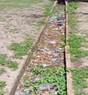 | 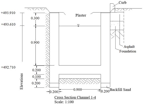 |  |
STA1+150 Channel (1-4) |  | 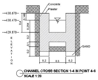 | 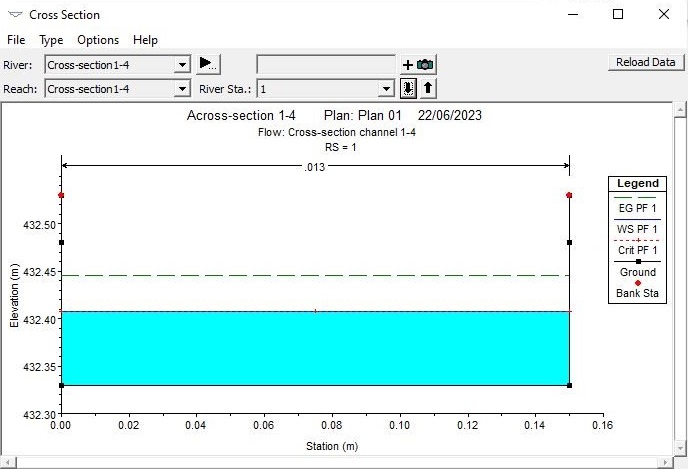 |
STA0+200 |  | 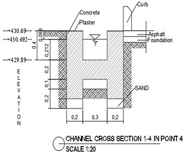 |  |
Regardless of the well's diameter, the infiltration well's measurement and the well's yield are determined by the groundwater flow rate and the hydraulic gradient created by the well's water level dip, as their method is Based on the necessary yield that restricts the entrance velocity of flow into the well to a range of 3 to 10 cm/s, the diameter of the infiltration well must be calculated. The well's diameter should typically be between 3.0 and 5.0 meters. Depth of the Well: The saturated thickness of the aquifer will be used to determine the well's depth. The healthy bottom must be sunk to a level with a clearance between the bottom of the curb and the aquifer equal to half the well's diameter if the aquifer's saturated thickness exceeds 8 meters. The well must be sunk to the aquifer's bottom or rock level and fastened to the rock if the aquifer's saturated thickness is less than 8 meters. Weep holes or porous concrete staining are two ways the aquifer's water is abstracted through good staining [29].
Because they enable rainwater runoff to seep into the earth rather than enter drainage networks immediately, infiltration wells are essential for sustainable drainage systems (as shown in Figure 7). This replenishes groundwater aquifers in an eco-friendly manner and lessens the hydraulic loading on the pipe and channel system. Intense rainstorms can overwhelm drainage systems in Bor County's seasonal tropical climate, resulting in urban floods. Roof runoff can be redirected into subsurface infiltration wells to collect enormous amounts of water and allow it to seep gently through the soil. Gravel-filled, perforated concrete chambers buried two to five meters deep makeup infiltration wells. These are positioned close to buildings so that drainpipes can collect roof runoff. While water seeps into the nearby soils, the wells serve as a temporary subsurface storage facility. The primary drainage network is linked to the overflow pipes at the top. Proper soil conditions are necessary for successful infiltration. Bor County is a good place for infiltration wells because of its high infiltration rates and excellent sandy loam soils. Soil tests are conducted to ascertain sufficient percolation and calculate the saturated hydraulic conductivity.
Retreatment is also essential via sedimentation pits or filter strips to prevent clogging and extend the functional life of the wells. Access ports are included for maintenance and inspection. Modeling ensures the wells can handle runoff from extreme storm events. For a new commercial development in Bor County, 10 infiltration wells reduced stormwater discharge to the local creek by over 70\%. This successfully mitigated downstream flooding while benefiting groundwater recharge. The infiltration wells also improve water quality by filtering sediments, nutrients, and pollutants. Infiltration wells are a proven technique for sustainable urban drainage design in Bor County. By diverting, storing, and soaking large volumes of runoff into the subsurface, infiltration wells help prevent destructive surface flooding while recharging groundwater supplies. Their performance depends on appropriate siting, soil testing, pre-treatment, and maintenance. Overall, they provide an environmentally sustainable solution for stormwater management.
Drop structures are essential for drainage channels to handle elevation changes and steep slopes. They allow water to be conveyed downhill and controlled without excessive velocities or erosion. For sustainable stormwater management in Bor County, drop structures help prevent flooding. The hilly terrain of Bor County means drainage channels often must traverse significant elevation drops, sometimes 5 meters or more. Stormwater runoff can accelerate downslope without proper grade control, gaining erosive energy. Drop structures provide fixed concrete weirs spaced periodically along the channel profile to dissipate energy incrementally. Water plunges over each weir into a plunge pool, where power is dissipated before flowing to the next drop. Common types used in Bor County are sharp-crested rectangular drop structures and broad-crested trapezoidal weirs (as shown in Figure 8). The rectangular weirs concentrate flow, providing maximum energy dissipation. The trapezoidal weirs offer a larger capacity. Drop height and length are designed based on the channel slope and flow velocities.
Drop structures control erosion by reducing the slope gradient between structures. The pools allow the settlement of sediments, while the weirs prevent head cutting and bed scour. Lining aprons and plunge pools with rock, concrete, or grouted riprap prevents local erosion. Proper hydraulic design of drop structures is essential to avoid flooding caused by undersized structures. Detailed modeling ensures adequate capacity, accounting for converging channel flows and overtopping of obvert weirs during major floods. For the drainage channel in Bor County, a series of 1.5-meter trapezoidal drop structures were optimized to allow a channel slope reduction from 6% to 15% without flooding. This successfully mitigated erosion and enabled the safe conveyance of urban stormwater. Drop structures transport water without eroding soil from one elevation to another. A low wall with a channel running the length of it.
It is called a drop structure (Canberra University, 2013). Various shapes, heights, and building materials are employed depending on their location and use. The terms grade controls, grade stabilizers, weirs, dams, and sills are frequently used to describe them. Drop structures are used to lower water velocity to non-erosive rates. When water flows, the slower water velocity causes sediment to be deposited between the structures, elevating and stabilizing the floor levels. The figures below show two main types of drop structures commonly used for drainage channels. Drop structures are a crucial component of sustainable urban drainage design in hilly Bor County. They provide controlled-grade transitions to safely convey storm flows downslope without erosion, helping prevent destructive flooding in settlements. Appropriate hydraulic design and hardening are essential for long-term functionality.
4. Results and Discussion
Bor County's SUDS design and construction considered several crucial factors to manage stormwater runoff and prevent flooding catastrophes. This included appropriate channel sizing, the incorporation of infiltration wells, and the use of drop structures for grade control. Detailed hydraulic modeling was performed to evaluate the system's performance.
The 10-year rainfall dataset reveals Bor experiences a distinct wet season from April to November, with a pronounced dry period from December to March. Maximum daily rainfall during wet months ranges from 926 mm/day to 1911 mm/day, with significant variability across different stations. For example, Rek faces extreme deluges nearing 2000 mm/day, requiring robust drainage infrastructure. This seasonal tropical pattern contrasts with more uniform, lower-intensity rainfall in developed countries. Bor's intense wet season concentrates heavy downpours over half the year, necessitating sufficient drainage capacity. Yet the extended dry period also creates water scarcity challenges, requiring capturing and storing wet season flows. Overall, Bor's climate underlines the need for a customized sustainable drainage approach focused on flood mitigation during the wet months and water conservation during the dry interval. Conventional temperate drainage methods may translate differently in this environment.
The channel dimensions for the SUDS were determined through hydrologic analysis of the 10-year rainfall data using rational method calculations. The design rainfall intensities for 2-year and 5-year return periods were found to be 73.82 mm/day and 93.08 mm/day, respectively. Using a runoff coefficient of 0.8 and a drainage area of 20 $km^2$, the peak discharges were calculated as 3 $m^3/s$ for the 2-year event and 5 $m^3/s$ for the 5-year event. The channel was then designed as a trapezoidal section lined with concrete. Manning's equation was used to size the channel depth and bottom width to convey the design flows. A Manning's n value of 0.015 was adopted based on the concrete lining. The resulting dimensions were a depth of 1.5 m and a bottom width of 2.0 m. The side slopes were set at 1:1 based on soil stability analysis.
The channel geometry was modeled in HEC-RAS to analyze the hydraulics in greater detail. The steady flow analysis feature was utilized to simulate the 2-year and 5-year design storm events. The flow data and boundary conditions were set based on the hydrologic analysis. The output water surface profiles demonstrated that the channel dimensions were adequate, with peak water depths of 1.2 m and 1.4 m for the 2-year and 5-year flows, respectively. The freeboard remained above the bank’s top at an elevation of 2.0 m. The cross-section plots also showed velocities within an acceptable 1-2 m/s range. Additional simulations also proved the channel capacity for 10-year and 25-year flows up to 10 $m^3/s$. The HEC-RAS model provides confidence in the trapezoidal channel design and its ability to safely convey stormwater and mitigate flooding.
The infiltration well is an essential part of the SUDS system for lowering runoff volumes entering the drainage network. They let water seep into the nearby sandy loam soils and offered temporary subterranean storage. Saturated 50–100 mm/h hydraulic conductivities were found in soil borings, showing appropriate permeability. Infiltration wells 3-5 meters deep and 2-3 meters in diameter are recommended based on this soil data. They should be situated near buildings to capture roof runoff. The modeling of a 0.5 ha commercial site with four infiltration wells showed a 70% reduction in runoff discharge. This significantly reduces hydraulic loading on the downstream channels and drainage system. Pre-treatment through filter strips and sedimentation pits will prevent clogging.
The hilly terrain in Bor County necessitates drop structures along the drainage channels to dissipate energy. As slopes increase, flow velocities can lead to excessive erosion. 1.5-meter-high trapezoidal drop structures spaced 50 meters apart were designed for drainage channels with 6–15\% slopes. The concrete weirs incrementally dissipate energy as flows drop into plunge pools. Channel lining and aprons reduce local scour. HEC-RAS modeling of the drop structures proved effective conveyance of the 25-year flow up to 20 $m^3/s$. The structures controlled the velocities at non-erosive rates below 2 m/s. No overtopping of the weirs was observed in the simulations. Proper integration of drop structures will enable Bor County's urban drainage channels to convey stormwater down sloped terrain safely without flood impacts. The sustainable drainage system for Bor County was designed through detailed hydrologic analysis, hydraulic modeling in HEC-RAS, the incorporation of infiltration wells, and the use of drop structures. The system provides robust management of stormwater runoff and flood mitigation capabilities. The multifaceted analysis and simulations validate the integrated drainage plan for Bor County's specific climate, topography, soils, and stormwater conditions.
No | Method | Room Scope | Anchoring Classification Water Runoff | Reason |
1 | Rain Garden | Source Limitations | Type of Storage and Type of Impregnation |
|
2 | Infiltration Strip | Source Limitations | Storage Type
| As a medium for absorbing runoff water, Type in a place where the surface infiltration is hardened and can be Infiltration wells |
3 | Water Roof | Source Regulators | Storage Type
|
|
4 | Rainwater Tank | Source controls | Storage Type |
|
5 | Cistern | Source controls | Storage Type | It is a reservoir for wastewater and can become raw, valuable water for a place during the dry season. |
6 | Swales | Site controls | Type of Storage and Type of Impregnation |
|
7 | Detention Basins | Site controls | Type of Storage and Type of Impregnation | Green open spaces in an area can hold and temporarily store significant surface water runoff during rain before being channeled. |
8
| Infiltration Trenches | Site control | Impregnation Types |
|
9 | Constructed Wetland | Site control | Storage Type | Artificial wetlands serve as habitat and biodiversity areas by imitating natural stormwater treatment and management techniques. |
10 | Urban Pond | Site control | Storage Type | Artificial ponds are designed to collect and manage stormwater while providing recreational and aesthetic benefits. |
The article analyzes numerous green infrastructure techniques used in developed countries, evaluating their potential for Bor County. Unsurprisingly, extensive retention ponds prevalent in temperate climates are less applicable to Bor's space constraints. However, smaller-scale sources and site controls emerge as promising options. Rain gardens, bio-retention cells, permeable pavements, and green roofs help capture and infiltrate runoff near the source. These decentralized elements dispersed across Bor's urban landscape could significantly reduce surface flows into the drainage network. Subsurface infiltration trenches and wells also allow groundwater recharge while alleviating hydraulic loads.
For conveyance, vegetated swales and channels slow velocities and enable infiltration. Where elevation drops require grade control, check dams and drop structures can dissipate erosive energy. Strategically placed detention basins and constructed wetlands offer storage and treatment of excess flows. Critically, most of these techniques involve relatively simple implementation and maintenance compared to large-scale gray infrastructure. This suits Bor's limited technical capacity and funding constraints. Incrementally integrating green elements into new developments is likely more feasible than major drainage system upgrades. Several suitable source and site control options are identified based on Bor's climate, topography, soils, and community needs. These practical techniques should be prioritized for pilot testing and demonstration projects to build experience and acceptance (as shown in Table 6).
It is possible to compare the sustainable drainage system methods, like the one shown in Table 3, in terms of area, storage volume, pollutant filtering, construction methods, maintenance, and costs after learning about the sustainable drainage system methods used in developed countries (as shown in Table 7) and those in developing countries like South Sudan, particularly in the city of Jonglei State, Bor.
When deciding which sustainable drainage system techniques to use in Bor City, consideration is given to the demands and specifications of the city's surface water runoff issues and the technical criteria of the technique's suitability for the city's field conditions. In addition to being considered from a technical standpoint, the foundation for selecting a method is also considered from the perspective of reasonably easy maintenance. Given the current circumstances, Table 4 presents drainage system techniques appropriate for Bor City, Jonglei State, South Sudan.
Identifying a sustainable drainage system appropriate for Bor County's implementation may be simpler by creating a plan like the one shown in Table 4. The locations of Bor city in Jonglei State are suggested for implementing a sustainable drainage system approach; these two sites were picked because they still have open areas that may be used to construct a sustainable drainage system, which helps lessen the effects of excessive surface water runoff and prevents flood disasters. By following this scheme, decision-makers can make informed choices that balance environmental, social, and economic considerations, ultimately leading to the implementation of sustainable drainage systems.
Comparison | Developed Countries | South Sudan |
|---|---|---|
Area | Requires a large space | The cross-sectional dimensions are minor and do not require a large area. |
Volume Container | Can accommodate the volume of water runoff with the large volume of surface runoff | It can only accommodate relatively little surface water. |
Filtering | Filter pollutants in runoff surface water | The filter cannot pollutants in surface water runoff |
Method processing | The work could be smoother. | Easy work |
Maintenance | Requires regular maintenance | Requires regular maintenance |
Cost | Manufacturing costs are expensive. | Economical manufacturing costs |
5. Conclusions
This study analyzed the potential for SUDS to reduce flood risks and provide co-benefits in Bor, South Sudan. Detailed hydrologic modeling using ten years of rainfall data showed Bor experienced intense seasonal deluges from April to November, with daily extremes reaching 1911 mm/day. This tropical pattern with prolonged wet months concentrates heavy runoff loads, increasing flooding vulnerability. A trapezoidal drainage channel was designed to mitigate flooding using Manning's equation. Key parameters were a depth of 1.5 m, a bottom width of 2.0 m, and concrete side slopes at 1:1. HEC-RAS hydraulic modeling validated the channel sizing for 2-year (3 $m^3/s$) and 5-year (5 $m^3/s$) flows. The resulting water surface elevations remained below the 2 m bank height. Additional simulations proved robust capacity up to the 25-year event (10 $m^3/s$). Infiltration wells with 2-3 m diameters and 3-5 m depths were recommended to reduce runoff volumes based on favorable soil conditions. The modeling of a 0.5 ha commercial site showed a 70% decrease in discharge when implementing four wells. 1.5-meter trapezoidal drop structures spaced at 50-meter intervals enabled controlled drainage on 6–15% slopes without erosion or flooding up to flows of 20 $m^3/s$. The integrated use of hydrologic analysis, HEC-RAS, infiltration wells, and drop structures produced a customized SUDS design for Bor. This system safely conveys stormwater, mitigates flooding, enhances groundwater recharge, and prevents erosion across Bor's variable climate and topography. Unlike conventional drainage, SUDS offers a sustainable solution by integrating decentralized green infrastructure into the urban landscape.
However, limitations exist in transferring SUDS approaches between developed and developing contexts. Design guidance from temperate climates may not suit tropical environments with intense seasonal rainfall, like Bor. Data constraints also necessitate simplified modeling assumptions. Further monitoring is needed to refine designs and account for long-term maintenance needs. Upfront capital costs may pose barriers to implementation, although life-cycle benefits could outweigh these expenses. This research demonstrates that SUDS can be adapted for secondary cities through an analysis of localized conditions. Success requires engagement with communities to build acceptance and ownership. Pilot projects should focus on practical techniques like rain gardens and permeable pavements that are low-cost and simple to construct and maintain. With strategic implementation, SUDS presents a promising strategy to increase climate resilience in rapidly urbanizing towns across South Sudan. Protecting vulnerable communities from destructive flooding will depend on sustainable stormwater management investments. This study initially evaluated SUDS potential in Bor, South Sudan's complex setting. The technical analysis offers actionable solutions, within acknowledged limitations, to mitigate flooding through customized sustainable drainage systems. With further research and community-driven pilot initiatives, SUDS can progress from concept to reality in Bor and similarly at-risk settlements. This will pave the way for sustainable stormwater management in the region, safeguarding lives and infrastructure.
Formal analysis: Abraham Ayuen Ngong Deng; Conceptualization: Nursetiawan Nursetiawan; Data curation: Nursetiawan Nursetiawan; and Supervision: Jazaul Ikhsan.
The data used to support the findings of this study are available from the corresponding author upon request.
The authors thank the University Muhammadiyah Yogyakarta, head of the Study Program for Scientific Research, for backing this study.
The authors declare that they have no conflicts of interest.